South East Point marks the southernmost tip of Wilsons Promontory National Park in Victoria's Gippsland region, jutting into Bass Strait at the confluence of the wild Southern Ocean and the calmer waters of the Prom's eastern bays. This dramatic granite headland is the mainland's southernmost point, fringed by exposed rocky reefs, deep surge channels, and giant boulder fields that have been sculpted by relentless swell. Snorkeling here is for the adventurous — the clear, nutrient-rich waters support dense kelp forests, crayweed, and sponge gardens that cling to the granite ledges.
South East Point
AdvancedMAYBE
MAYBE
Fair. Experienced snorkellers only.
Showing last known conditions
Wave Height 0.2 mSwell Period 11 sWind Speed 11 knPrecipitation 25 mmTidal Phase flood
Last evaluated
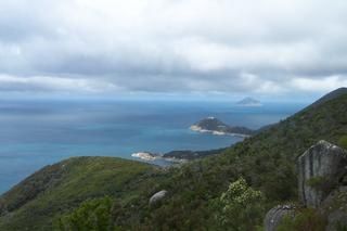 © Gaz at en.wikipedia
DANGER: Explicit Risks Present
South East Point has hazards marked as danger. Entering the water here means you may face serious risks to your personal safety.
- Southern Ocean Swell danger
Large, powerful swells from the Southern Ocean and Bass Strait pound the exposed coastline year-round, creating dangerous surging conditions on the rocky reefs.
The spot
Community-maintained
Community contribution: submitted by Daniel
Know before you go
Logged by the community, confirmed by mods
High risk: Southern Ocean Swell
Large, powerful swells from the Southern Ocean and Bass Strait pound the exposed coastline year-round, creating dangerous surging conditions on the rocky reefs.
Moderate risk: Strong Wind Chop
South-westerly winds can whip up sudden white-capped chop and reduced visibility, especially in spring and summer afternoons.
Moderate risk: Surging Reef & Boulder Terrain
Granite boulder fields and deep surge channels create entrapment hazards; waves can push snorkelers forcefully against rocks.
Moderate risk: Remote Location & No Lifeguards
South East Point is a wilderness area with no on-site rescue services, no mobile reception in many spots, and limited emergency access.
Moderate risk: Strong currents
Strong currents can develop near the headland, especially during outgoing tides. Swimmers and snorkelers should stay alert and avoid venturing too far from shore.
Low risk: Cold Water Temperature
Bass Strait waters are persistently cold (12-16°C), with risk of hypothermia without a thick wetsuit, hood, gloves, and booties.
Low risk: Submerged rocks and drop-offs
Granite boulders are submerged near the point with sudden depth changes. Entry and exit require care to avoid slips and trips on slippery rocks.
Wildlife Guide
No wildlife notes for this spot yet.
Gallery
1 photo from the community
Getting in
Shore entry
Entry
From Melbourne, take the M1/M420 to the South Gippsland Highway, continue through Meeniyan and Foster to Fish Creek. Follow the Promontory Road (C444) into Wilsons Promontory National Park. Drive to the Tidal River visitor area. From Tidal River, it's a challenging 19 km one-way hike along the Promontory Track to South East Point (overnight hike required). There is no vehicle access to the point itself.
Parking & facilities
Park at Tidal River car park (fee applies for park entry). Overnight hikers can leave vehicles at the Tidal River overflow lot. No parking at South East Point.
toiletsparkingdrinking_watershowers
Wilsons Promontory National Park entry fee applies (per vehicle, per day).
Spot Map
Community
Gallery ┬╖ 1 photos
Trust
Is this spot real, accurate, still loved?
Spots near Victoria

No nearby spots yet.
Needs verification
Quick verify
One tap helps the community keep this spot honest.
About this data
- Conditions last evaluated
- Spot data last updated
- Data sources
- Open-Meteo (marine & weather conditions), tide predictions via UTide, community contributors (descriptions, hazards, marine life).
- License
- Spot content licensed under CC BY-SA 4.0. How's the Spot is open source.
Weather & swell ┬╖ Open-Meteo marine & weather APIs Tides ┬╖ UTide harmonic analysis Sea & safety ┬╖ community reports