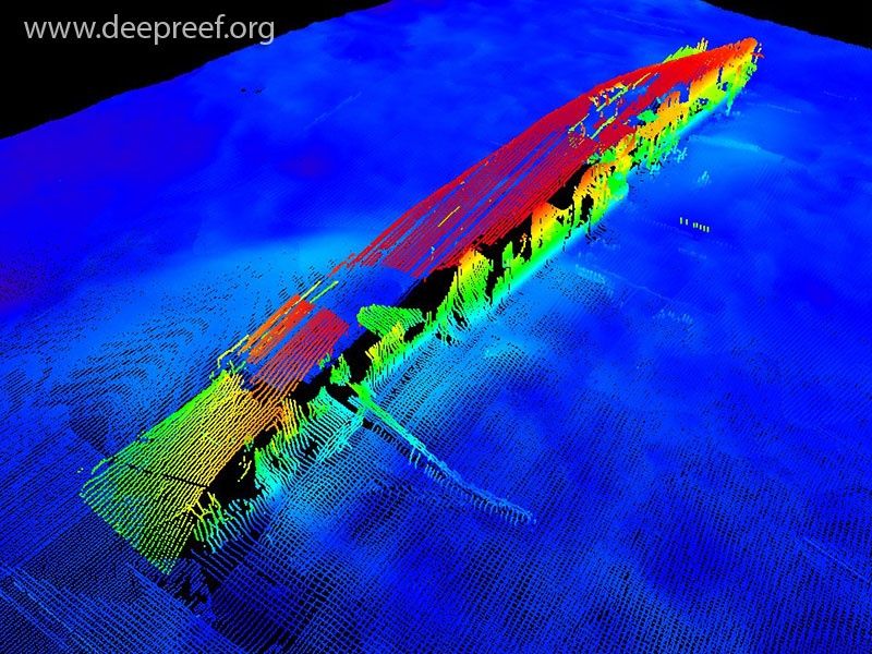
The RMS Quetta is a remarkably intact 3,302-ton iron-hulled steamship wreck lying on its port side in just 18 metres of water in the remote Adolphus Channel at the tip of Cape York. Sunk in 1890 after striking an uncharted rock, the wreck now teems with marine life, offering divers a rare chance to explore open cargo holds, cavernous rooms, and the massive gash that doomed the ship. Massive groupers, manta rays, clouds of batfish, and schools of sweetlips congregate here, while barracuda and sharks patrol above. Strong 4-knot currents require diving only on slack water — a narrow, once-daily window — making this a truly adventurous dive for experienced divers visiting via Thursday Island or liveaboard.
RMS Quetta Wreck
AdvancedGO
GO
It's a go.
Showing last known conditions
Wave Height 0.0 mSwell Period 3.1 sWind Speed 8.9 knPrecipitation 0.6 mmTidal Phase flood
Last evaluated
DANGER: Explicit Risks Present
RMS Quetta Wreck has hazards marked as danger. Entering the water here means you may face serious risks to your personal safety.
- Strong Tidal Currents danger
The area experiences extreme tidal currents exceeding 4 knots. Diving is only possible during a brief slack water window that occurs once daily.
The spot
Community-maintained
Community contribution: submitted by Daniel
Know before you go
Logged by the community, confirmed by mods
High risk: Strong Tidal Currents
The area experiences extreme tidal currents exceeding 4 knots. Diving is only possible during a brief slack water window that occurs once daily.
Moderate risk: Remote Location
The wreck lies in a remote area far from emergency medical facilities. The nearest hyperbaric chamber is on Thursday Island or Cairns.
Moderate risk: Wreck Entanglement Hazard
The iron wreck structure is over 130 years old with sharp edges, collapsed sections, and entanglement hazards within the interior holds.
Low risk: Boat Access Only
The site is accessible only by boat, requiring a boat trip from Thursday Island or a liveaboard. Weather and sea conditions can change rapidly in Torres Strait.
Wildlife Guide
No wildlife notes for this spot yet.
Gallery
2 photos from the community
Getting in
Boat
Entry
The wreck lies about 1 nautical mile southwest of Quetta Rock in the Adolphus Channel, Torres Strait, Cape York. Access is by boat from Thursday Island (approx. 30 min) or as part of a multi-day liveaboard trip from Cairns. Club dive operators on Thursday Island may offer trips — contact via social media or local dive clubs.
Parking & facilities
N/A — no parking on site. Parking available at Thursday Island marina if self-arranging boat transport.
Spot Map
Community
Gallery ┬╖ 2 photos
Trust
Is this spot real, accurate, still loved?
Spots near Queensland

No nearby spots yet.
Needs verification
Quick verify
One tap helps the community keep this spot honest.
About this data
- Conditions last evaluated
- Spot data last updated
- Data sources
- Open-Meteo (marine & weather conditions), tide predictions via UTide, community contributors (descriptions, hazards, marine life).
- License
- Spot content licensed under CC BY-SA 4.0. How's the Spot is open source.
Weather & swell ┬╖ Open-Meteo marine & weather APIs Tides ┬╖ UTide harmonic analysis Sea & safety ┬╖ community reports