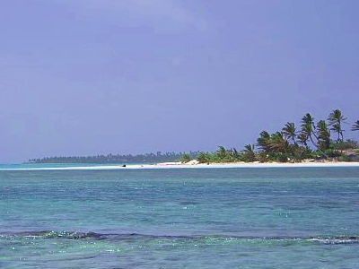
Prison Island is a small, ever-changing sandy cay wedged between Home Island and Direction Island in the southern Cocos (Keeling) atoll. Once crowned with towering coconut palms, it has been reshaped by the elements into a low-lying sandbar. The northern tip offers a spectacular drift snorkel through a vibrant fish nursery, where schools of juvenile fish swarm the crystal-clear lagoon waters. Best experienced on a local tour, this spot delivers a true off-the-beaten-path Indian Ocean adventure.
Prison Island
IntermediateMAYBE
MAYBE
Fair. Experienced snorkellers only.
Showing last known conditions
Wave Height 0.7 mSwell Period 5.6 sWind Speed 13 knPrecipitation 25 mmTidal Phase slack
Last evaluated
The spot
Community-maintained
Community contribution: submitted by Daniel
Know before you go
Logged by the community, confirmed by mods
Moderate risk: Tidal current drift
The northern tip of Prison Island is known for a drift snorkel through a fish nursery. The tidal current can be strong, sweeping snorkelers along the channel. Best experienced on a guided tour that times the tide correctly.
Low risk: Sun exposure / no shade
Prison Island is a small sandy cay with no shade, fresh water, or facilities. Exposure to the tropical sun can be extreme.
Low risk: Shifting sandbar / erosion
The island's shape and size change seasonally due to erosion and shifting sands. Navigation and landing conditions can vary.
Wildlife Guide
No wildlife notes for this spot yet.
Gallery
1 photo from the community
Getting in
Snorkel tour
Entry
Prison Island lies between Home Island and Direction Island in the southern atoll of the Cocos (Keeling) Islands. Access is best arranged via a local boat tour from West Island or Home Island; the island is not connected by a public ferry.
Parking & facilities
Parking available at West Island accommodation or Home Island jetty. The island itself has no vehicle access or parking facilities — it is a small sandy cay with no infrastructure.
Accessible only via paid local tour operators; no public ferry service.
Spot Map
Community
Gallery ┬╖ 1 photos
Trust
Is this spot real, accurate, still loved?
Nearby spots

No nearby spots yet.
Needs verification
Quick verify
One tap helps the community keep this spot honest.
About this data
- Conditions last evaluated
- Spot data last updated
- Data sources
- Open-Meteo (marine & weather conditions), tide predictions via UTide, community contributors (descriptions, hazards, marine life).
- License
- Spot content licensed under CC BY-SA 4.0. How's the Spot is open source.
Weather & swell ┬╖ Open-Meteo marine & weather APIs Tides ┬╖ UTide harmonic analysis Sea & safety ┬╖ community reports