The Omeo Wreck is the centrepiece of the Coogee Maritime Trail, an artificial snorkelling trail along Perth's Coogee Beach. The iron-hulled steamship Omeo came adrift from Fremantle port in 1905 and ran aground, with its remains now lying just 25 metres offshore in 2–5 metres of water. Over 55 submerged structures — including reef pyramids, a swim-through sculpture, replica cannon, and underwater educational plaques — guide snorkelers around the wreck site. The sternpost and bow section protrude from the water, while the surrounding artificial reef teems with fish, stingrays, and the occasional passing seal or dolphin. The shallow, protected waters make this an ideal spot for novice snorkelers and families.
Omeo Wreck (Coogee Maritime Trail)
BeginnerMAYBE
MAYBE
Fair. Experienced snorkellers only.
Showing last known conditions
Wave Height 0.6 mSwell Period 11 sWind Speed 1.8 knPrecipitation 0.6 mmTidal Phase ebb
Last evaluated
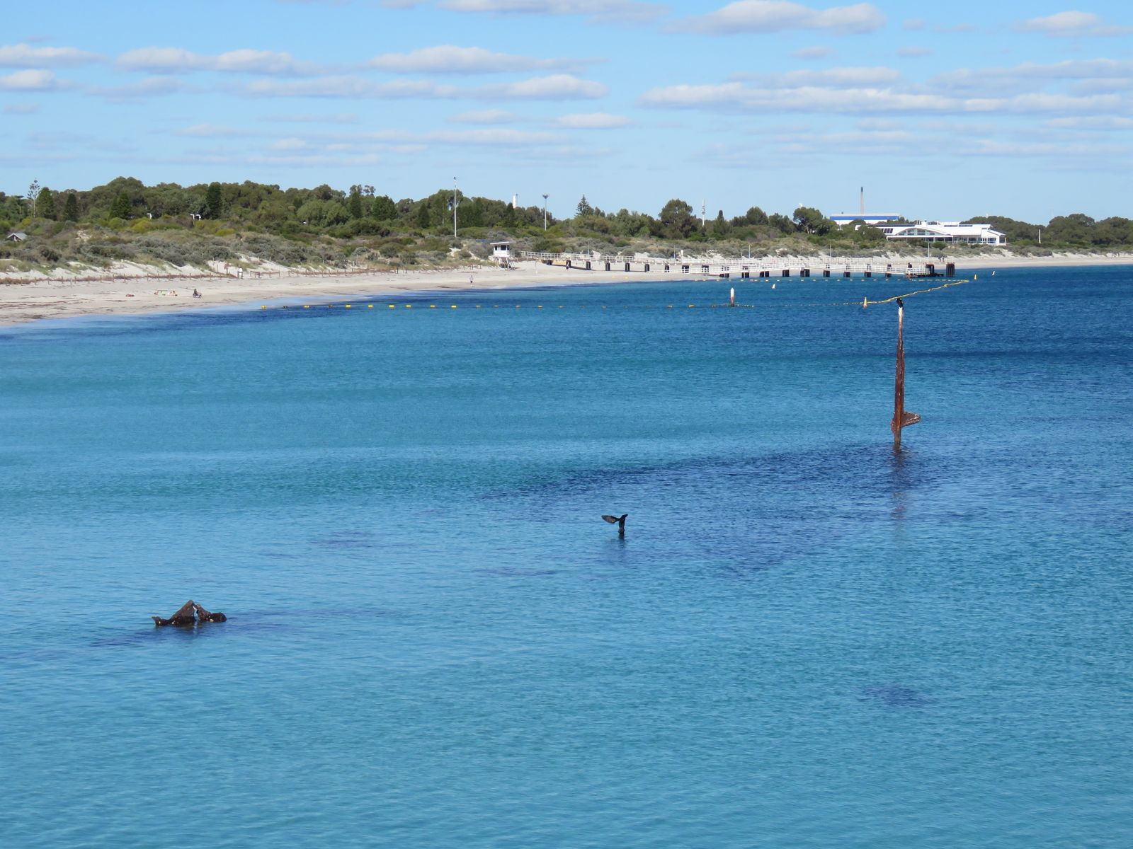 © Calistemon
The spot
Community-maintained
Community contribution: submitted by Daniel
Know before you go
Logged by the community, confirmed by mods
Moderate risk: Sharp wreckage
The Omeo is an aging iron wreck with collapsed sections and protruding metal. Snorkelers should avoid contact and never climb on the wreck.
Moderate risk: Protected heritage — do not climb
Climbing or standing on the wreck is prohibited and can cause damage to this protected maritime heritage site.
Moderate risk: Climbing restriction
The wreck is fragile and protected — climbing on the structure is prohibited and can cause injury or damage.
Moderate risk: Shallow Wreck Structure
The Omeo wreck has sharp metal edges and protruding sections. Snorkelers should avoid climbing on the fragile wreck to prevent cuts and preserve the site.
Moderate risk: Sharp metal and entrapment risk
The wreck structure has protruding metal, sharp edges and sections that could cause cuts or entanglement if snorkellers venture inside without proper training.
Moderate risk: Protected wreck – do not climb
The wreck is a protected heritage site. Climbing, standing on, or touching the wreck is prohibited and can cause injury from sharp, rusted metal edges.
Moderate risk: Sharp wreck debris
The Omeo wreck has broken metal and timber sections. Climbing on the wreck is prohibited and sharp edges pose a cut hazard if contact is made.
Low risk: Boat traffic near trail markers
The trail is close to shore but boats may pass through the area; remain vigilant and use surface markers.
Low risk: Reduced visibility after wind/swell
Coogee Beach is generally sheltered, but windy days or increased swell can stir up sediment, reducing visibility significantly.
Low risk: Low water temperature in winter
Winter water temperatures drop, requiring a wetsuit for comfort and safety.
Low risk: Sharp reef and wreck debris
The Omeo wreck and artificial reef structures may have sharp edges; rash guard or wetsuit recommended.
Low risk: Shallow reef structures
The trail is very shallow (2–5 m) so snorkelers must be mindful not to kick or stand on the reef modules and wreck structure.
Low risk: Reduced visibility in swell
On windy days or during southerly swells visibility can drop to less than a metre, making navigation difficult.
Low risk: Boat traffic
The wreck is only 25m offshore but the area is used by recreational boats and jet skis, especially on weekends. Snorkelers should stay within the marked trail zone.
Low risk: Rough swell and wind
Coogee Beach is generally protected but when wind or swell picks up, visibility drops significantly (to a few feet) making navigation difficult.
Low risk: Shallow submerged structures
Reef modules and the wreck itself sit in only 2–5 m of water. Snorkelers should take care not to collide with submerged metal and concrete structures.
Low risk: Cold water temperatures
Winter water temperatures can drop, requiring a wetsuit for comfortable snorkeling.
Low risk: Boat traffic in breakwater channel
The trail follows the southern breakwater where boat traffic may be present near the channel entrance.
Low risk: Low visibility after wind/swell
Wind and swell stir up sediment, reducing visibility — best on calm, low-wind days.
Low risk: Sharp wreck/reef structures
The Omeo wreck and artificial reef modules have exposed metal and sharp edges that can cause cuts.
Low risk: Afternoon wind chop
Westerly afternoon winds can stir up the water, reducing visibility significantly. Best visited in calm morning conditions.
Low risk: Outgoing tide current
Tidal flow can create a gentle current near the wreck; swimmers should be aware and stay within their limits.
Low risk: Boating traffic
The wreck is close to the Port Coogee marina entrance — boat traffic may be present in the vicinity.
Low risk: Poor visibility in swell
When wind or swell picks up, the shallow site gets stirred up, dramatically reducing visibility.
Low risk: Afternoon sea breeze
Wind from the south-west can create choppy surface conditions, reducing visibility and making snorkelling more challenging.
Low risk: Tidal currents
Strong currents can occasionally develop around the wreck structure, particularly during tidal changes.
Low risk: Strong onshore winds
Southerly winds can create choppy surface conditions and reduce visibility in the shallow waters around the wreck.
Low risk: Poor visibility in windy weather
Snorkeling in stirred-up or windy conditions reduces visibility to near zero. Check conditions before entering.
Low risk: Afternoon sea breeze chop
Swell patterns and wind chop can build in Cockburn Sound, especially in afternoon sea breezes.
Low risk: Vessel traffic
Boat traffic in the adjacent Port Coogee Marina and recreational vessels in the Sound.
Low risk: Swell and wind chop
On windy days the shallow bay can become stirred up, reducing visibility to only a couple of feet. Avoid snorkeling when wind or swell is up.
Wildlife Guide
No wildlife notes for this spot yet.
Gallery
8 photos from the community
Getting in
Shore entry
Entry
Located at the northern end of Coogee Beach in the Port Coogee development. Head to Socrates Parade, North Coogee, approximately 30 km (45 min) south of Perth city centre. Park on Socrates Parade right next to the beach. The wreck is visible just 25 m offshore in shallow water.
Parking & facilities
Street parking available on Socrates Parade directly adjacent to Coogee Beach.
parkingtoiletsshowerspicnic_tables
Free entry. No fees for snorkeling.
Spot Map
Community
Gallery ┬╖ 8 photos
Trust
Is this spot real, accurate, still loved?
Spots near Western Australia

No nearby spots yet.
Needs verification
Quick verify
One tap helps the community keep this spot honest.
About this data
- Conditions last evaluated
- Spot data last updated
- Data sources
- Open-Meteo (marine & weather conditions), tide predictions via UTide, community contributors (descriptions, hazards, marine life).
- License
- Spot content licensed under CC BY-SA 4.0. How's the Spot is open source.
Weather & swell ┬╖ Open-Meteo marine & weather APIs Tides ┬╖ UTide harmonic analysis Sea & safety ┬╖ community reports