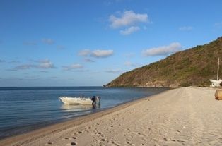
Maʼalpiku Island National Park (also known as Restoration Island) is a remote continental island rising 116 m from the turquoise waters of Far North Queensland, crowned with granite boulders, paperbark scrub, and wind-sheared heath. Its fringing reefs — part of the Great Barrier Reef World Heritage Area — wrap the island in a ribbon of coral gardens, offering snorkelers a pristine, off-the-beaten-track experience. This is where Captain Bligh and the Bounty loyalists landed in 1789, revived by the island's oysters and native fruits. The surrounding waters are clear, warm, and brimming with coral bommies, making it a wild, uncrowded alternative to the more frequented reef sites.
Maʼalpiku Island National Park (fringing reefs)
IntermediateGO
GO
It's a go.
Showing last known conditions
Wave Height 0.2 mSwell Period 3.5 sWind Speed 8.8 knPrecipitation 1.8 mmTidal Phase flood
Last evaluated
DANGER: Explicit Risks Present
Maʼalpiku Island National Park (fringing reefs) has hazards marked as danger. Entering the water here means you may face serious risks to your personal safety.
- Remote location danger
Remote location with no on-site medical facilities; emergency evacuation would be difficult.
- Estuarine crocodiles danger
Crocs may be present in nearshore waters of Far North Queensland, especially near river mouths and mangroves.
The spot
Community-maintained
Community contribution: submitted by Daniel
Know before you go
Logged by the community, confirmed by mods
High risk: Remote location
Remote location with no on-site medical facilities; emergency evacuation would be difficult.
High risk: Estuarine crocodiles
Crocs may be present in nearshore waters of Far North Queensland, especially near river mouths and mangroves.
Moderate risk: Tidal currents
The fringing reefs are exposed to the open Coral Sea and can experience strong tidal flows around the island, especially during spring tides.
Moderate risk: Marine stingers
Marine stingers (box jellyfish and Irukandji) are prevalent in tropical Queensland waters during the warmer months.
Wildlife Guide
No wildlife notes for this spot yet.
Gallery
1 photo from the community
Getting in
Boat
Entry
Maʼalpiku Island (Restoration Island) lies a few hundred metres off Cape Weymouth in Far North Queensland, approximately 1,928 km northwest of Brisbane. Access is by private or charter boat from the Iron Range / Cape Weymouth area. No public ferry service.
Parking & facilities
Parking available at boat ramps near Iron Range / Cape Weymouth.
No fees for the national park itself; boat access costs vary by charter.
Spot Map
Community
Gallery ┬╖ 1 photos
Trust
Is this spot real, accurate, still loved?
Spots near Queensland

No nearby spots yet.
Needs verification
Quick verify
One tap helps the community keep this spot honest.
About this data
- Conditions last evaluated
- Spot data last updated
- Data sources
- Open-Meteo (marine & weather conditions), tide predictions via UTide, community contributors (descriptions, hazards, marine life).
- License
- Spot content licensed under CC BY-SA 4.0. How's the Spot is open source.
Weather & swell ┬╖ Open-Meteo marine & weather APIs Tides ┬╖ UTide harmonic analysis Sea & safety ┬╖ community reports