Keswick Island, fringed by the Great Barrier Reef, offers 20 named dive and snorkel sites ranging from shallow coral gardens at Connie Bay and Coral Gardens to swim-through caves, deep canyons, and four known shipwreck sites. The island's leeward side provides sheltered conditions with vibrant coral bommies and bommie fields. The diversity of terrain — from easy shore-entry snorkelling in the shallows to more advanced drift dives over deeper reef walls — makes it a standout destination in the Whitsundays & Mackay region. Green, hawksbill, flatback and loggerhead turtles are commonly seen, along with manta rays, Maori wrasse, and humpback whales during migration season.
Keswick Island dive sites (20 named sites)
BeginnerGO
GO
It's a go.
Showing last known conditions
Wave Height 0.1 mSwell Period 2.3 sWind Speed 14 knPrecipitation 0.0 mmTidal Phase flood
Last evaluated
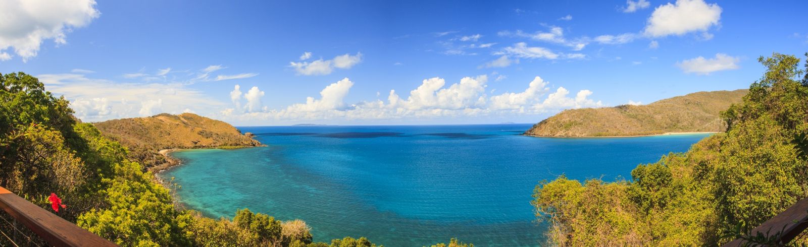 © Stuart McAndrew Photos
DANGER: Explicit Risks Present
Keswick Island dive sites (20 named sites) has hazards marked as danger. Entering the water here means you may face serious risks to your personal safety.
- Venomous marine life (cone shells, stonefish, blue-ringed octopus) danger
Cone shells, blue-ringed octopus, and stonefish inhabit the reef and are deadly if touched or stepped on. Look but do not touch.
The spot
Community-maintained
Community contribution: submitted by Daniel
Know before you go
Logged by the community, confirmed by mods
High risk: Venomous marine life (cone shells, stonefish, blue-ringed octopus)
Cone shells, blue-ringed octopus, and stonefish inhabit the reef and are deadly if touched or stepped on. Look but do not touch.
Moderate risk: Stingers (jellyfish)
Marine stingers (box jellyfish and Irukandji) are present in tropical Queensland waters, particularly during the warmer months.
Moderate risk: Strong tidal currents in passage
The passage between Keswick and neighbouring islands can develop strong tidal currents. Snorkelers should stay close to shore and avoid the channel.
Moderate risk: Marine stingers (jellyfish)
Marine stingers (jellyfish) are present in these tropical waters, with peak season from November to May.
Moderate risk: Strong tidal currents in the passage
Strong tidal currents run through the passage between Keswick and neighbouring islands. Swimming in the passage is not recommended.
Moderate risk: Marine stingers (box jellyfish)
Marine stingers (box jellyfish) are present in these tropical waters, particularly during the warmer months.
Moderate risk: Tidal currents in reef channels
Strong tidal currents can run through the reef channels around Keswick Island, particularly during spring tides. Snorkelers should be aware of changing water movement and plan their sessions around slack tide.
Moderate risk: Remote location — no lifeguard
Limited facilities and no on-site lifeguard services. Snorkellers should be self-sufficient and carry safety equipment.
Moderate risk: Stinger season (box jellyfish)
Marine stingers including box jellyfish are present in the warmer months. Stinger suits are strongly recommended.
Moderate risk: Tidal currents in channels
Strong tidal currents can develop in the channels around Keswick Island, particularly between the island and the mainland. Snorkellers should be aware of changing tide conditions.
Moderate risk: Sharp wreckage and debris
The wreck structure is broken up with sharp, corroded metal edges and debris that can cause cuts or entanglement.
Moderate risk: Strong currents in Egremont Passage
Strong currents run through Egremont Passage between Keswick and St Bees Island. Snorkelling along the shore towards Horseshoe Bay and at Coral Gardens is safe, but swimming in the passage itself is not recommended.
Moderate risk: Egremont Passage Current
Strong currents flow through Egremont Passage between Keswick and neighbouring St Bees Island. Not recommended for swimming.
Moderate risk: Marine Stingers
Marine stingers (including Irukandji and bluebottles) have been reported, particularly at Connie Bay. Bluebottles are occasional during king tides.
Moderate risk: Cyclones
Keswick Island lies in the Queensland tropical cyclone zone. Cyclones can occur between November and April.
Moderate risk: Remote location – limited services
Keswick Island is remote with no medical facilities. Visitors must be self-sufficient.
Low risk: Tidal currents
Strong tidal currents can flow through the channels around Keswick Island, particularly between the island and the mainland. Snorkelers should be aware of changing tide conditions.
Low risk: Marine traffic
Boat traffic in the surrounding waters, especially during peak season, as the island is accessed by private vessels and charter boats.
Low risk: Sharp coral and reef
Coral and rocky reef formations can cause cuts and abrasions if touched. Swimmers should avoid standing on coral and be aware of surge zones near the reef edge.
Low risk: Marine stingers
Marine stingers (box jellyfish and Irukandji) are present in tropical Queensland waters during the warmer months, peaking Nov-May.
Low risk: Boat traffic
Boat traffic in the channel and around the island, particularly from ferries, charter vessels, and private boats accessing the marina.
Low risk: Ocean surge and currents
Surge and currents can be strong around the reef fringe, especially at exposed sites and during tidal changes.
Low risk: Surge
Strong water movement can be present around the wreck, particularly during changing tides, requiring good buoyancy control.
Low risk: Current
Tidal currents can develop around the wreck site, especially during spring tides.
Low risk: Deep wreck sites (8–16 m)
Some wreck sites lie at depths of 8–16 m, requiring good buoyancy control and awareness of depth limits for snorkelers.
Low risk: Sharp coral
Sharp coral and rocky reef edges are common at the wreck and reef sites.
Low risk: Shallow reef at low tide
The fringing reef is exposed and very shallow at low tide, making it difficult to snorkel over coral without damaging it or scraping yourself.
Low risk: Outgoing tide current
Strong outflow currents can develop in channels between the island and the mainland, particularly around the northern and eastern points.
Low risk: Humpback whale migration
Humpback whales migrate through the waters off Keswick Island from June to September — boat traffic and whale presence require caution.
Low risk: Remote location
Limited medical facilities on the island. The nearest hospital is in Mackay, a 90-minute boat ride away.
Low risk: Remote location with no lifeguards
Limited on-island facilities mean snorkelers must be self-sufficient. No lifeguards are present on the reef fringe.
Low risk: Low tide shallow reef
At low tide the fringing reef becomes very shallow, exposing coral heads and reducing navigable swimming areas. Snorkellers should take care to avoid coral contact.
Low risk: Marine Park Regulations
Located in a Great Barrier Reef Green Zone — no fishing or collecting. Vessel access restrictions apply.
Low risk: Tidal currents around reef points
Some areas of the reef have strong tidal flows, especially around the island's points and channels. Snorkel with caution during outgoing tides.
Low risk: Shallow coral and sharp reef
The reef has shallow coral bommies and plate corals close to shore; avoid contact to prevent injury and protect the reef.
Low risk: Shipwreck hazards
Shipwreck sites and deeper reef features present entanglement and disorientation risks for inexperienced snorkelers.
Low risk: Shark presence
Reef sharks are occasionally sighted near Basil Bay. These are timid and generally avoid humans. Bull and tiger sharks have been reported in Egremont Passage — more aggressive species to be aware of.
Low risk: Coral cuts and infection risk
Sharp coral cuts are common and can become infected quickly. Treat even minor scratches with disinfectant immediately.
Low risk: Sharks
Bull and tiger sharks have been reported in Egremont Passage. Reef sharks in Basil Bay are timid but present.
Low risk: Coral Cuts
Coral cuts can quickly become infected. Treat even small scratches with disinfectant immediately.
Low risk: Sharp coral and rocky bommies
The reef fringe can have sharp coral and shallow bommies, requiring care to avoid injury.
Wildlife Guide
No wildlife notes for this spot yet.
Gallery
1 photo from the community
Getting in
Boat
Entry
Keswick Island is located in the southern Great Barrier Reef, approximately 30 km northeast of Mackay, Queensland. The island is accessible by private boat or charter. Multiple tour operators from Mackay offer day trips, including snorkel tours that visit Keswick Island's dive sites. The island has a small airstrip for private aircraft.
Parking & facilities
Parking available at the Mackay Marina or boat ramps on the mainland before charter departure.
toilets
Access via private boat is free; charter/snorkel tour costs vary (typically $150–$250 AUD per person for a full-day reef tour from Mackay).
Spot Map
Community
Gallery ┬╖ 1 photos
Trust
Is this spot real, accurate, still loved?
Spots near Queensland

No nearby spots yet.
Needs verification
Quick verify
One tap helps the community keep this spot honest.
About this data
- Conditions last evaluated
- Spot data last updated
- Data sources
- Open-Meteo (marine & weather conditions), tide predictions via UTide, community contributors (descriptions, hazards, marine life).
- License
- Spot content licensed under CC BY-SA 4.0. How's the Spot is open source.
Weather & swell ┬╖ Open-Meteo marine & weather APIs Tides ┬╖ UTide harmonic analysis Sea & safety ┬╖ community reports