An archipelago of 122 islands scattered across three coral-reef groups — Wallabi, Easter and Pelsaert — lying 60 km west of Geraldton in the Indian Ocean. Often called the Galápagos of the Indian Ocean, the Abrolhos are a snorkeling wilderness of crystalline shallows, bomboras, and vibrant coral reefs nourished by the warm Leeuwin Current. Pristine lagoons teem with tropical and temperate marine life, while the translucent waters reveal a submerged world of colourful coral bommies, limestone caves, and historic shipwreck relics. Access is exclusively by scenic flight, live-aboard cruise, or private charter, making every visit feel like a true expedition.
Houtman Abrolhos Islands (Abrolhos Islands)
IntermediateSKIP
SKIP
Poor conditions. Stay out today.
Showing last known conditions
Wave Height 1.6 mSwell Period 11 sWind Speed 0.7 knPrecipitation 0.4 mmTidal Phase ebb
Last evaluated
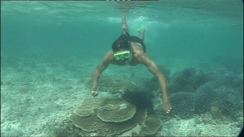 © Ernie Dingo
DANGER: Explicit Risks Present
Houtman Abrolhos Islands (Abrolhos Islands) has hazards marked as danger. Entering the water here means you may face serious risks to your personal safety.
- Remote location and cold shock danger
The islands are 60 km offshore with no immediate medical facilities; sudden cold water upwelling can cause shock and impair swimming ability.
The spot
Community-maintained
Community contribution: submitted by Daniel
Know before you go
Logged by the community, confirmed by mods
High risk: Remote location and cold shock
The islands are 60 km offshore with no immediate medical facilities; sudden cold water upwelling can cause shock and impair swimming ability.
Moderate risk: Strong currents (Leeuwin Current)
The warm Leeuwin Current flows strongly past the islands, creating powerful tidal streams between the reef systems that can sweep snorkelers offshore.
Moderate risk: Strong ocean currents
The warm Leeuwin Current and tidal flows through channels between islands can create strong, unpredictable currents that challenge even experienced snorkelers.
Moderate risk: Remote location
Located 60 km offshore with limited emergency services; medical evacuation can take hours. Self-sufficiency and proper planning are essential.
Moderate risk: Strong ocean currents (Leeuwin Current)
The warm Leeuwin Current flows strongly through the archipelago and can sweep snorkelers away from sheltered areas. Always snorkel with a guide or tour operator.
Moderate risk: Remote offshore location
The islands are 60 km from the mainland with no medical facilities. Emergencies require helicopter evacuation. Self-reliance and tour accompaniment are essential.
Moderate risk: Tidal currents between islands
Strong tidal flows run between the islands and reefs, particularly around passage channels. Snorkelers should be aware of changing currents.
Low risk: Sharp coral and limestone reef
Extensive shallow coral reefs and limestone formations with sharp edges pose a cut hazard to bare skin, especially in surge zones.
Low risk: Marine stingers
Box jellyfish and other marine stingers are occasionally present in warmer months.
Low risk: Boat traffic in narrow passages
Fishing charter and cruise vessels operate in confined channels between islands; snorkelers must stay vigilant in marked navigation lanes.
Low risk: Boat traffic
Charter boats, fishing vessels and tour operators navigate the same waters as snorkelers. Be aware of boat lanes near mooring areas.
Low risk: Sharp coral and reef edges
Extensive coral gardens have sharp edges that can cause cuts and abrasions. Protective footwear and careful finning are recommended.
Low risk: Marine stingers (box jellyfish)
Tropical marine stingers may be present during warmer months. Wearing a stinger suit is advised from November to April.
Low risk: Cold water temperatures (May–October)
The Abrolhos experience a Mediterranean climate with chilly ocean temperatures (16-22°C) outside summer months. Cold water shock is a risk for unprepared snorkelers.
Low risk: Shark presence (including white sharks)
The islands are a known white shark aggregation area. Snorkelers should follow local advisories and avoid seals haul-outs.
Low risk: Boat traffic at mooring sites
Some snorkeling sites require open-water crossings and boat access only; unsupervised swimming near boat ramps and moorings carries entanglement risk.
Wildlife Guide
No wildlife notes for this spot yet.
Gallery
3 photos from the community
Getting in
Boat
Entry
The Abrolhos Islands lie 60 km west of Geraldton, WA. No public ferry service exists. Access is by scenic flight from Geraldton Airport (Shine Aviation) or Kalbarri (Nationwest/Kalbarri Scenic Flights) with day-tour ground components, or by live-aboard cruise (Eco Abrolhos Cruises offers 5-day voyages; Pelican Charters offers 3-5 day fishing/snorkel charters). Private vessels can make the crossing from Geraldton (Boat Harbour) or Port Gregory, but navigation is challenging and weather-dependent.
Parking & facilities
Park at Geraldton Boat Harbour car park if arriving by private vessel, or at Geraldton Airport long-term parking for scenic flight departures. No parking exists on the islands themselves.
toilets
Access to the National Park is free. Scenic flights: ~$350-500/person; live-aboard cruises: $1,500-2,500+ for multi-day trips.
Spot Map
Community
Gallery ┬╖ 3 photos
Trust
Is this spot real, accurate, still loved?
Spots near Western Australia

No nearby spots yet.
Needs verification
Quick verify
One tap helps the community keep this spot honest.
About this data
- Conditions last evaluated
- Spot data last updated
- Data sources
- Open-Meteo (marine & weather conditions), tide predictions via UTide, community contributors (descriptions, hazards, marine life).
- License
- Spot content licensed under CC BY-SA 4.0. How's the Spot is open source.
Weather & swell ┬╖ Open-Meteo marine & weather APIs Tides ┬╖ UTide harmonic analysis Sea & safety ┬╖ community reports