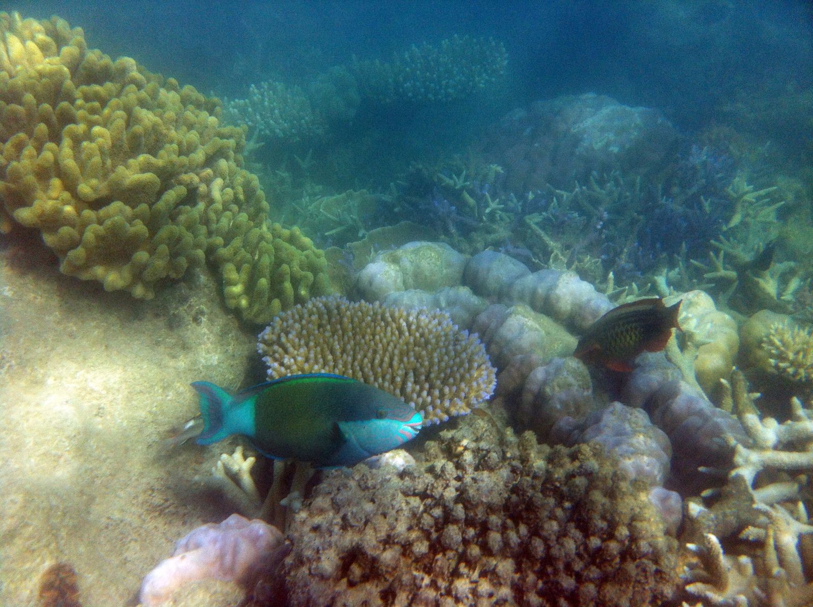
Hook Island, part of the Whitsundays group in the Great Barrier Reef Marine Park, is a snorkeler's haven defined by its fringing reefs and sheltered bays. The star attraction is Mantaray Bay (nicknamed 'The Aquarium'), where thousands of friendly Yellow-tail Fusiliers, Maori Wrasse, Giant Trevally, and Batfish swirl around visitors in crystal-clear water. Other notable snorkel sites include Wrasse Bay with its coral gardens, Luncheon Bay with gentle sandy entry, and the renowned Pinnacles dive site off the island's northeastern tip. The coral here suffered damage from Cyclone Debbie but remains vibrant in patches, with the fish life being the main draw. The island is uninhabited and accessible only by boat, offering a truly wild, remote Great Barrier Reef experience.
Hook Island (northern coast coral gardens)
It's a go.
Showing last known conditions
Last evaluated
The spot
Community-maintained
Community contribution: submitted by Daniel
Know before you go
Logged by the community, confirmed by mods
Moderate risk: Northerly wind exposure
Sites like Mantaray Bay and Wrasse Bay are fully exposed to northerly winds. Even a light northerly breeze creates unsafe conditions.
Moderate risk: Strong tidal currents
Tidal currents can be severe, especially in Wrasse Bay and around Pinnacle Point. Strong currents also make overnight stays inadvisable in Mantaray Bay.
Moderate risk: Stinger season
Marine stingers (box jellyfish and Irukandji) are present in Whitsunday waters during the warmer months.
Moderate risk: Tidal currents
Tidal currents can be severe, especially in Wrasse Bay and around Pinnacle Point. Strong currents may sweep snorkelers away from their entry point.
Moderate risk: Marine Stingers (Jellyfish)
Stinger season in the Whitsundays brings marine stingers (box jellyfish and Irukandji). A stinger suit is highly recommended during the warmer months.
Moderate risk: Strong tidal currents and swell
Strong tidal currents can develop around the bays, especially in Wrasse Bay and near Pinnacle Point. Swell can roll in unexpectedly.
Low risk: Sharp coral beach
Mantaray Bay's beach is composed of sharp broken coral fragments that are painful to walk on, and only accessible at high tide.
Low risk: Unexpected swell
Swell can roll in unexpectedly at exposed bays like Wrasse Bay, particularly problematic during low tide when moorings are close to the reef.
Low risk: Marine stingers
Marine stingers (box jellyfish and Irukandji) are present in Whitsunday waters from October to May.
Low risk: Boat traffic
Boat traffic in popular bays with moorings. Snorkelers should be vigilant of tenders and tour vessels entering and leaving the area.
Low risk: Manta Ray Encounters
Manta rays are frequently spotted in the bay during winter. While generally harmless, they can be startled by sudden movements. Maintain a respectful distance and avoid touching.
Low risk: Damaged Coral (Post-Cyclone)
Like all Whitsundays sites, the reef was impacted by Cyclone Debbie (2017). Some coral areas remain fragile or damaged. Avoid standing on or touching coral to prevent further harm.
Low risk: Shallow reef at low tide
Manta Ray Bay is accessible only by shallow-draft vessels at mid to high tide. The reef edges are shallow and can be hazardous at low tide for boats and swimmers.
Low risk: Manta ray presence (seasonal)
Winter months (May to September) bring manta rays into the bay. While not aggressive, they are large animals and should be given respectful distance.
Low risk: Recovering coral reef (post-cyclone)
The bay suffered significant coral damage from Cyclone Debbie in March 2017. Some reef areas are still recovering; coral can be sharp or unstable.
Low risk: Mooring time limits
Mooring time limits are strictly enforced at 2 hours per mooring. Vessels must move or leave after the limit. Anchoring is prohibited in green zone areas.
Low risk: Tidal currents at exposed points
Strong currents can develop around the points between bays, particularly on an outgoing tide. Stick to the sheltered inner bays.
Low risk: Marine stingers (jellyfish)
Stinging marine stingers (box jellyfish and Irukandji) are present in the Whitsundays during the warmer months (October to May).
Low risk: Boat traffic in mooring zones
Vessel traffic from charter boats, yachts, and tenders entering and leaving the mooring areas.
Low risk: Shallow coral reef at low tide
The coral reef fringing the island can be very shallow, especially at low tide. Snorkelers must be cautious not to stand on or damage coral.
Low risk: Sharp coral rubble beach
Beaches are predominantly composed of crushed coral rubble, which can be sharp and uncomfortable underfoot.
Low risk: Tender mooring hazards at low tide
Small tender moorings in Mantaray Bay are not designed for low tide use and may damage boats or the reef below.
Wildlife Guide
No wildlife notes for this spot yet.
Gallery
4 photos from the community
Getting in
Hook Island is part of the Whitsunday Islands, accessible only by boat from Airlie Beach or Hamilton Island. Most visitors join a day tour or charter a yacht. The northern coast coral gardens (Mantaray Bay, Butterfly Bay, Luncheon Bay) are visited by commercial snorkel tours departing Airlie Beach daily.
Park at the Port of Airlie or Abel Point Marina car parks in Airlie Beach (paid parking available). No parking on Hook Island itself.
National park camping fees apply for overnight stays. Day tours range from $150-$250 AUD per person.
Spot Map
Community
Trust
Is this spot real, accurate, still loved?
Spots near Queensland

No nearby spots yet.
Quick verify
One tap helps the community keep this spot honest.
About this data
- Conditions last evaluated
- Spot data last updated
- Data sources
- Open-Meteo (marine & weather conditions), tide predictions via UTide, community contributors (descriptions, hazards, marine life).
- License
- Spot content licensed under CC BY-SA 4.0. How's the Spot is open source.