Nestled along the Indian Ocean Drive three hours north of Perth, Green Head's sheltered bays — including the near-circular Dynamite Bay (ranked #19 in Australia's Top 101 Beaches) — offer pristine white silica sand and crystal-clear turquoise water protected by limestone headlands. Point Louise provides a reef break with excellent snorkelling over seagrass meadows, while South Bay stretches 6.5 km along an uncrowded coastline. The warm Leeuwin Current nurtures limestone reefs, hard and soft corals, and diverse marine life within easy swim from shore. Three bays are linked by the scenic 2.8 km Three Bays Walkway with multiple lookout points.
Green Head Beaches / Snorkel Bays
BeginnerSKIP
SKIP
Poor conditions. Stay out today.
Showing last known conditions
Wave Height 1.9 mSwell Period 11 sWind Speed 0.7 knPrecipitation 0.7 mmTidal Phase ebb
Last evaluated
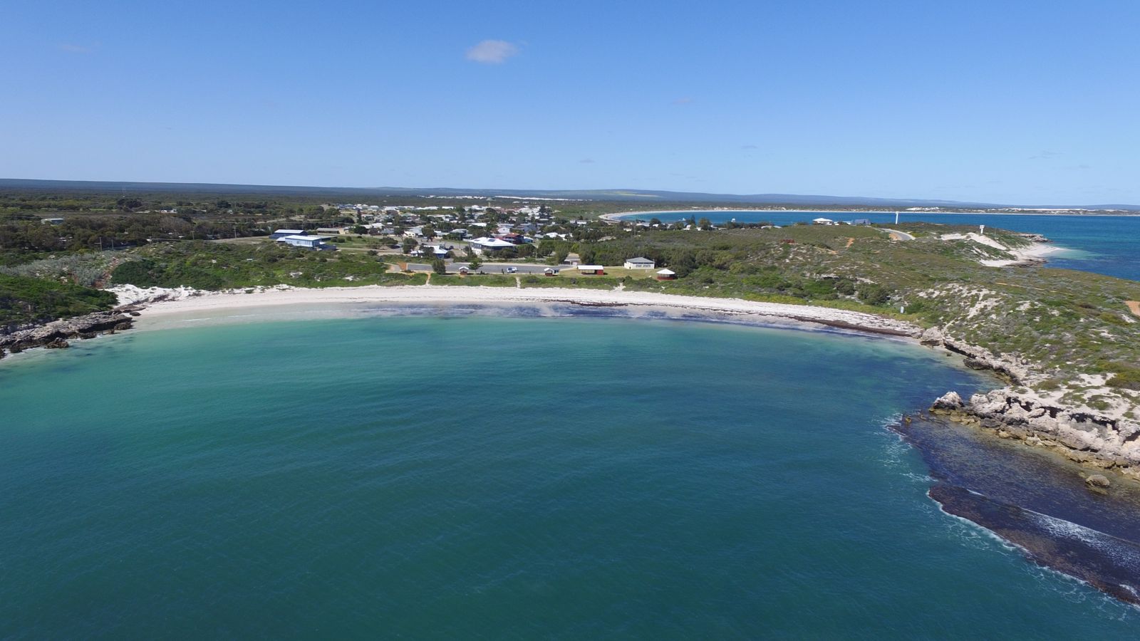 © SoCWdev18
The spot
Community-maintained
Community contribution: submitted by Daniel
Know before you go
Logged by the community, confirmed by mods
Moderate risk: Rough reef breaks at Point Louise
Point Louise has a reef break that can produce strong surf conditions, unsuitable for inexperienced snorkelers when swell is up.
Moderate risk: Shipwreck reef hazards
Several Dutch shipwrecks (Gilt Dragon, Waeckende Boey) lie on the reefs — submerged wreckage can present entanglement or sharp metal hazards for divers.
Low risk: Rocky peninsula walk
The rocky headland can be sharp and slippery when wet; wear sturdy footwear if walking out for views.
Low risk: Offshore winds
Winds can pick up suddenly outside the sheltered bay, creating choppy conditions for those venturing beyond the protected area.
Low risk: Rocky shoreline at peninsula
The rocky cliff and peninsula areas can be slippery and sharp underfoot when exploring outside the sheltered bay.
Low risk: Fishing activity
Fishing lines and tackle are sometimes present in the water, posing entanglement and hook risks for snorkelers.
Low risk: Rocky edges
The bay is flanked by low rocky cliffs and a rocky peninsula; sharp rocks near the shoreline require care when entering or exiting the water.
Low risk: Rocky peninsula outcrops
The rocky cliff that shelters the bay has jagged sections along the peninsula walk — sharp edges near the waterline at the bay's edges.
Low risk: Offshore wind and swell beyond the bay
While the bay itself is calm, winds and swell pick up significantly just beyond the protective rocky cliff. Snorkellers should stay within the sheltered bay area.
Low risk: Seagrass debris accumulation
South Bay has seagrass meadows 50 m offshore; large amounts of seagrass debris can accumulate in the northern corner near the boat launch area.
Low risk: Surf break at Point Louise
Point Louise has a reef break that activates during large outside swells, creating stronger conditions unsuitable for inexperienced swimmers.
Low risk: Limestone reef hazards
Sharp limestone reef formations are present offshore, particularly around Point Louise and offshore islands; care needed when entering and exiting the water.
Low risk: Reef sharp edges
Shallow limestone and coral reefs can have sharp edges; reef shoes recommended when entering or exiting the water.
Low risk: Swell surge at exposed bays
South Bay and Anchorage Bay can experience ocean swell surge, especially in winter months, creating stronger water movement near the reef.
Low risk: Boat traffic at South Bay
South Bay has a boat ramp and recreational jetty; be aware of boat movements in this area.
Low risk: Sea lion mating season tour restrictions
Sea lion tours are often unavailable during August when Australian Sea Lions are mating. Fisherman's Island breeding colony has restricted access.
Low risk: Reef break surf at Point Louise
Point Louise has a good reef break that can create challenging conditions for inexperienced swimmers and snorkellers when the swell is up.
Low risk: Limited facilities at remote bays
South Bay and some of the more secluded bays have limited facilities; visitors should bring their own water and supplies.
Low risk: Restricted access to Fisherman's Island
Fisherman's Island is an Australian Sea Lion breeding colony with restricted access — unauthorised landing is prohibited and tours may not operate during August mating season.
Low risk: Offshore current from Leeuwin Current
The warm Leeuwin Current flows southward past the offshore reefs and can create unexpected drift conditions for snorkelers and divers.
Wildlife Guide
No wildlife notes for this spot yet.
Gallery
6 photos from the community
Getting in
Shore entry
Entry
Green Head is 250 km north of Perth via Indian Ocean Drive (approx. 2 hr 45 min drive). Turn west off Indian Ocean Drive onto Green Head Road and follow to the coastal town centre.
Parking & facilities
Large car parks at Dynamite Bay with long-vehicle bays; Cliff Park at South Bay also has parking with long-vehicle bays. Surfers Point Break car park is above Point Louise beach.
toiletsparkingshowerspicnic_tables
No fees for beach access. Milligan Island eco-camping $15 per car per night.
Spot Map
Community
Gallery ┬╖ 6 photos
Trust
Is this spot real, accurate, still loved?
Spots near Western Australia

No nearby spots yet.
Needs verification
Quick verify
One tap helps the community keep this spot honest.
About this data
- Conditions last evaluated
- Spot data last updated
- Data sources
- Open-Meteo (marine & weather conditions), tide predictions via UTide, community contributors (descriptions, hazards, marine life).
- License
- Spot content licensed under CC BY-SA 4.0. How's the Spot is open source.
Weather & swell ┬╖ Open-Meteo marine & weather APIs Tides ┬╖ UTide harmonic analysis Sea & safety ┬╖ community reports