Stretching along the dramatic Bunda Cliffs of the Nullarbor coastline, the Great Australian Bight Marine Park offers wild, remote snorkeling and diving over a vast temperate carbonate platform. This UNESCO-recognised area protects globally significant soft-sediment ecosystems teeming with sponges, ascidians, and bryozoans, while inshore waters serve as a critical calving ground for endangered southern right whales (June–October). Snorkelers explore crystal-clear shallows above seafloor gardens of colourful invertebrates and small reef fish. Access is via the long Nullarbor crossing to Head of Bight, where viewing platforms overlook the marine park. The powerful Southern Ocean swells, cold currents, and remote location demand self-sufficiency and experience.
Great Australian Bight Marine Park (snorkeling/diving areas)
Poor conditions. Stay out today.
Showing last known conditions
Last evaluated
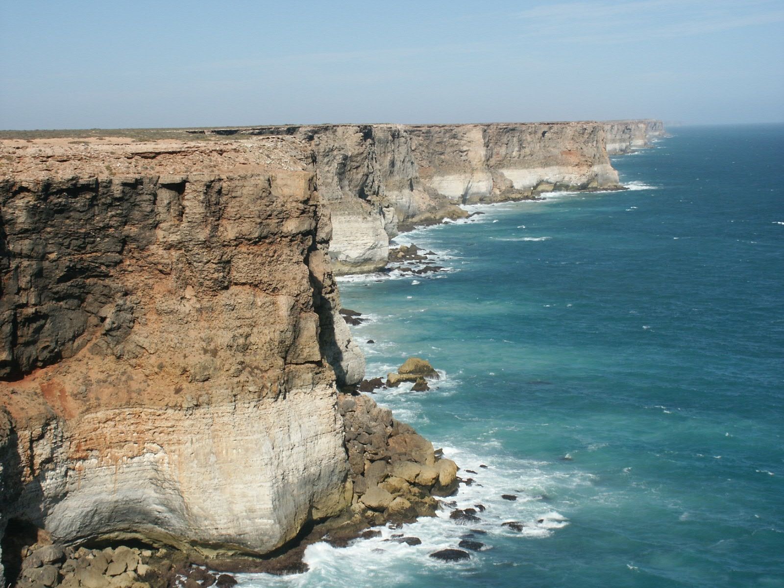 © Nachoman-au
DANGER: Explicit Risks Present
Great Australian Bight Marine Park (snorkeling/diving areas) has hazards marked as danger. Entering the water here means you may face serious risks to your personal safety.
- Powerful Southern Ocean swells danger
Large, unpredictable swells can create dangerous surge conditions along the exposed cliff-base entry points.
- Strong offshore currents danger
Rip and longshore currents can quickly sweep swimmers away from entry points into open ocean.
- Remote and isolated location danger
Hundreds of kilometres from emergency services and medical facilities along the Nullarbor Plain.
- Sheer Cliff Faces danger
The Bunda Cliffs rise up to 100 m vertically from the ocean, making shore landings dangerous or impossible in most areas.
- Strong Ocean Swells & Currents danger
Exposed to the full force of the Southern Ocean, the area experiences powerful swells, unpredictable currents, and rapidly changing weather.
- Southern Ocean Swell danger
Powerful open-ocean swells and large breaking waves pound the coastline, creating dangerous surf conditions year-round.
- Steep Cliff Access danger
Access to the water is via unstable, crumbling limestone cliffs with no formal stairs or lifelines — extreme caution required.
- Strong ocean currents and swell danger
The Great Australian Bight is exposed to powerful Southern Ocean swells and unpredictable currents that can quickly sweep swimmers away from shore.
- Remote location & limited emergency access danger
The area is extremely isolated along the Nullarbor — the nearest medical facility is hours away by road, and mobile phone coverage is virtually nonexistent.
- Sheer cliff access danger
Access to the water is along steep, unstable limestone cliffs (the Bunda Cliffs) with no easy entry points — shore-based snorkeling is extremely hazardous.
The spot
Community-maintained
Community contribution: submitted by Daniel
Know before you go
Logged by the community, confirmed by mods
High risk: Powerful Southern Ocean swells
Large, unpredictable swells can create dangerous surge conditions along the exposed cliff-base entry points.
High risk: Strong offshore currents
Rip and longshore currents can quickly sweep swimmers away from entry points into open ocean.
High risk: Remote and isolated location
Hundreds of kilometres from emergency services and medical facilities along the Nullarbor Plain.
High risk: Sheer Cliff Faces
The Bunda Cliffs rise up to 100 m vertically from the ocean, making shore landings dangerous or impossible in most areas.
High risk: Strong Ocean Swells & Currents
Exposed to the full force of the Southern Ocean, the area experiences powerful swells, unpredictable currents, and rapidly changing weather.
High risk: Southern Ocean Swell
Powerful open-ocean swells and large breaking waves pound the coastline, creating dangerous surf conditions year-round.
High risk: Steep Cliff Access
Access to the water is via unstable, crumbling limestone cliffs with no formal stairs or lifelines — extreme caution required.
High risk: Strong ocean currents and swell
The Great Australian Bight is exposed to powerful Southern Ocean swells and unpredictable currents that can quickly sweep swimmers away from shore.
High risk: Remote location & limited emergency access
The area is extremely isolated along the Nullarbor — the nearest medical facility is hours away by road, and mobile phone coverage is virtually nonexistent.
High risk: Sheer cliff access
Access to the water is along steep, unstable limestone cliffs (the Bunda Cliffs) with no easy entry points — shore-based snorkeling is extremely hazardous.
Moderate risk: Cold water temperatures
Year-round cold water (12-16°C) risks hypothermia without proper exposure protection.
Moderate risk: Marine Mammal Protection Area restriction
Vessel access prohibited from 1 May to 31 October to protect southern right whale breeding activity.
Moderate risk: Remote & Isolated Access
The nearest infrastructure is at Head of Bight, a 20-min detour off the Eyre Highway across the Nullarbor. No services exist on the water.
Moderate risk: Cold Southern Ocean Waters
Water temperatures are very cold year-round, increasing risk of hypothermia even in summer.
Moderate risk: Marine Mammal Protection Area Closure
All vessels are prohibited from entering the whale sanctuary at the head of the Bight from 1 May to 31 October.
Moderate risk: Strong Rips and Currents
Unpredictable rip currents along the exposed Bight coastline can sweep swimmers offshore rapidly.
Moderate risk: Remote Isolation
The nearest medical facilities are hundreds of kilometres away, with no cell reception across vast stretches. Self-sufficiency is essential.
Moderate risk: Cold Southern Ocean temperatures
Water temperatures rarely exceed 15°C even in summer, posing hypothermia risk without adequate exposure protection.
Moderate risk: Great white shark presence
The Bight is a known habitat for great white sharks, which frequent seal and sea lion colonies along the Bunda Cliffs.
Low risk: Cold Water Temperature
Water temperatures drop as low as 10–12 °C (50–54 °F) in winter, increasing risk of hypothermia even with a wetsuit.
Wildlife Guide
No wildlife notes for this spot yet.
Gallery
3 photos from the community
Getting in
The primary access point is Head of Bight, reached via the Eyre Highway (Nullarbor crossing) — approximately 1,200 km west of Adelaide or 800 km east of Norseman. Turn off the highway onto the Head of Bight access road and follow signs to the visitor platform and cliff-top viewing area.
Gravel carpark at Head of Bight visitor centre. Suitable for cars, campervans, and caravans. No overnight camping permitted in the carpark.
Head of Bight visitor centre entry fee applies (check current rates). No additional fee for the marine park itself.
Spot Map
Community
Trust
Is this spot real, accurate, still loved?
Spots near South Australia

No nearby spots yet.
Quick verify
One tap helps the community keep this spot honest.
About this data
- Conditions last evaluated
- Spot data last updated
- Data sources
- Open-Meteo (marine & weather conditions), tide predictions via UTide, community contributors (descriptions, hazards, marine life).
- License
- Spot content licensed under CC BY-SA 4.0. How's the Spot is open source.