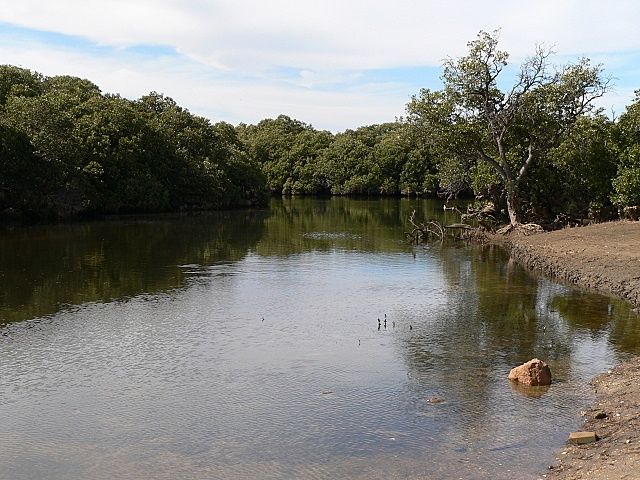
The Gawler River Mangroves (Port Gawler) offer a truly unique snorkeling experience — you float through shallow, tea-coloured tidal channels winding through a dense grey mangrove (Avicennia marina) forest on the northern fringe of Gulf St Vincent. This remarkable ecosystem acts as a vital nursery for juvenile fish, crabs, and rays, with the mangrove roots forming an intricate underwater labyrinth. The water has a distinct brown-yellow hue from tannins and sediment, different from open-ocean snorkeling, and depths range from just 1 to 3 metres. Guided tours run seasonally, making this an accessible and otherworldly adventure just 40 minutes north of Adelaide.
Gawler River Mangroves (Port Gawler)
IntermediateGO
GO
It's a go.
Showing last known conditions
Wave Height 0.1 mSwell Period 7.1 sWind Speed 9.0 knPrecipitation 18 mmTidal Phase ebb
Last evaluated
 © Fairv8
The spot
Community-maintained
Community contribution: submitted by Daniel
Know before you go
Logged by the community, confirmed by mods
Moderate risk: Tidal Currents
The river channels have a tidal range of up to 2 metres. Snorkelling against an outgoing or incoming tide can be strenuous and dangerous.
Low risk: Silty Bottom / Low Visibility
The silty riverbed is easily stirred up by fins, drastically reducing visibility (down to near-zero). Snorkellers must keep their feet off the bottom at all times.
Low risk: Disorientation in Mid-Channel
The middle of the channel lacks features and has a disorienting silt-and-light effect, which can cause confusion for inexperienced snorkellers.
Low risk: Snag / Submerged Debris Hazard
Fallen trees, submerged branches, and mangrove roots protrude beneath the surface, posing a risk of entanglement or injury if not carefully avoided.
Low risk: Muddy/Slippery Bottom
The mangrove floor is soft mud and can be very slippery when entering or exiting the water.
Low risk: Shallow Water Depth
Mangrove channels are very shallow, requiring careful finning to avoid disturbing the bottom or injuring marine life.
Low risk: Outgoing Tide Current
Current can pick up as the tide goes out through the narrow mangrove channels, potentially drifting snorkelers.
Low risk: Submerged mangrove roots & debris
Mangrove roots and submerged branches at low tide create entanglement risk — stay aware of your surroundings.
Low risk: Soft muddy bottom / poor visibility
Muddy substrate and soft sediment underfoot makes standing difficult; water turns murky if disturbed.
Low risk: Reduced visibility (tannin-stained water)
Tannin-stained brown-yellow water can make it difficult to see submerged obstacles and differentiate depth.
Wildlife Guide
No wildlife notes for this spot yet.
Gallery
4 photos from the community
Getting in
Shore entry
Entry
Approximately 40 minutes north of Adelaide. Take Port Wakefield Road (A1) north, turn left onto Port Gawler Road and follow it toward the coast. The mangrove area is accessed near the Gawler River mouth at Port Gawler.
Parking & facilities
Limited unsealed roadside parking near the Gawler River bridge/Port Gawler area.
Spot Map
Community
Gallery ┬╖ 4 photos
Trust
Is this spot real, accurate, still loved?
Spots near South Australia

No nearby spots yet.
Needs verification
Quick verify
One tap helps the community keep this spot honest.
About this data
- Conditions last evaluated
- Spot data last updated
- Data sources
- Open-Meteo (marine & weather conditions), tide predictions via UTide, community contributors (descriptions, hazards, marine life).
- License
- Spot content licensed under CC BY-SA 4.0. How's the Spot is open source.
Weather & swell ┬╖ Open-Meteo marine & weather APIs Tides ┬╖ UTide harmonic analysis Sea & safety ┬╖ community reports