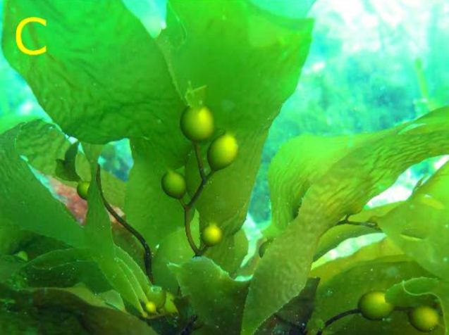
Fortescue Bay, on the Tasman Peninsula, is one of the last remaining snorkelling sites in eastern Tasmania where you can swim among towering Giant Kelp (Macrocystis pyrifera) — an endangered marine community that has declined by over 95%. The shallow kelp forest rises from depths of 3–12 m, creating a cathedral-like underwater world of golden-green stalks and drifting canopy. Clear, cool water offers views of colourful reef fish, rock lobsters, and abundant invertebrates sheltering among the kelp fronds. A restoration project (OzFish/Kelp Tracker) is actively working to replant this iconic forest, making every visit a chance to witness both natural wonder and conservation in action.
Fortescue Bay (Giant Kelp Forest)
BeginnerGO
GO
It's a go.
Showing last known conditions
Wave Height 0.5 mSwell Period 11 sWind Speed 2.3 knPrecipitation 1.6 mmTidal Phase slack
Last evaluated
The spot
Community-maintained
Community contribution: submitted by Daniel
Know before you go
Logged by the community, confirmed by mods
Moderate risk: Cold water temperatures
Water temps range 11–18°C year-round. A 7mm wetsuit or drysuit is strongly recommended even in summer.
Low risk: Variable visibility
Visibility can change rapidly with swell, wind, and runoff. Check conditions before entering.
Low risk: Boat traffic
Fortescue Bay has a boat ramp and is popular with fishing boats. Snorkellers should stay aware and use a dive float.
Wildlife Guide
No wildlife notes for this spot yet.
Gallery
3 photos from the community
Getting in
Shore entry
Entry
Fortescue Bay is located within the Tasman National Park on the Tasman Peninsula, about 1.5 hours' drive east of Hobart. Follow the Arthur Highway (A9) from Hobart towards Port Arthur, then turn onto Fortescue Bay Road. The road winds 12 km through forest to reach the bay.
Parking & facilities
Large carpark available near the beach adjacent to the campground. Can fill up during summer and holiday periods.
parkingtoiletspicnic_tablesboat_ramp
Tasman National Park entry fees apply — check Parks Tasmania website for current day pass or holiday pass costs.
Spot Map
Community
Gallery ┬╖ 3 photos
Trust
Is this spot real, accurate, still loved?
Spots near Tasmania

No nearby spots yet.
Needs verification
Quick verify
One tap helps the community keep this spot honest.
About this data
- Conditions last evaluated
- Spot data last updated
- Data sources
- Open-Meteo (marine & weather conditions), tide predictions via UTide, community contributors (descriptions, hazards, marine life).
- License
- Spot content licensed under CC BY-SA 4.0. How's the Spot is open source.
Weather & swell ┬╖ Open-Meteo marine & weather APIs Tides ┬╖ UTide harmonic analysis Sea & safety ┬╖ community reports