The ex-HMAS Tobruk is a 127-metre former Royal Australian Navy landing ship scuttled on 29 June 2018 in 28.5 metres of water, now resting on its starboard side as Queensland's premier artificial reef dive wreck. Located roughly 31 km offshore between Bundaberg and Hervey Bay in the Great Sandy Marine Park, this colossal wreck offers a jaw-dropping swim-through tank deck that runs nearly the full 120-metre length of the ship. Depths range from 12 metres at the shallowest point to 30 metres on the seafloor. A designated area requiring permits, the site is accessible only by boat via guided tour operators, and is already being reclaimed by encrusting marine life, soft corals, and schooling fish.
Ex-HMAS Tobruk
AdvancedMAYBE
MAYBE
Fair. Experienced snorkellers only.
Showing last known conditions
Wave Height 0.0 mSwell Period 0.0 sWind Speed 3.4 knPrecipitation 0.0 mmTidal Phase flood
Last evaluated
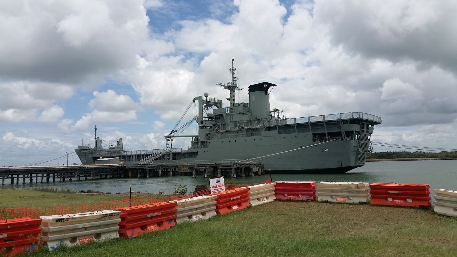 © Nighthaze3320
DANGER: Explicit Risks Present
Ex-HMAS Tobruk has hazards marked as danger. Entering the water here means you may face serious risks to your personal safety.
- Depth hazard danger
Wreck sits at up to 28.5 m depth on starboard side — requires advanced scuba certification; snorkellers limited to surface viewing.
- Pentrating wreck hazards danger
Wreck interior has entanglement risks, silt, and limited exits; penetration requires advanced wreck diving certification.
- Wreck Penetration Hazards danger
Enclosed spaces, sharp metal edges, overhead environments, silt-out risk, and entanglement hazards inside the wreck compartments.
- Restricted Access Area danger
Entry to the Ex-HMAS Tobruk designated area is prohibited without a permit or written approval — applies to all vessels, divers and snorkellers.
- Depth and pressure danger
The wreck sits approximately 30 m below surface, posing decompression and gas narcosis risks for inexperienced divers.
- Restricted access zone danger
Entry to the designated Ex-HMAS Tobruk area is prohibited without a permit or written approval — applies to all vessels, divers and snorkellers.
- Depth — 27 metres danger
The wreck rests at 27m depth; requires recognised scuba diving qualification and strict dive planning. Snorkelling is not feasible at this depth.
- Enclosed spaces / overhead environment danger
Penetration into the wreck's interior carries entanglement and entrapment risks. Only certain areas are open; advanced wreck training recommended.
- Restricted Entry Zone danger
The entire ex-HMAS Tobruk area is a designated zone; entry requires a permit or written approval — recreational access is strictly controlled.
- Restricted access without permit danger
The site is a designated area in the Great Sandy Marine Park; entry is prohibited without a permit or written approval from the managing authority.
The spot
Community-maintained
Community contribution: submitted by Daniel
Know before you go
Logged by the community, confirmed by mods
High risk: Depth hazard
Wreck sits at up to 28.5 m depth on starboard side — requires advanced scuba certification; snorkellers limited to surface viewing.
High risk: Pentrating wreck hazards
Wreck interior has entanglement risks, silt, and limited exits; penetration requires advanced wreck diving certification.
High risk: Wreck Penetration Hazards
Enclosed spaces, sharp metal edges, overhead environments, silt-out risk, and entanglement hazards inside the wreck compartments.
High risk: Restricted Access Area
Entry to the Ex-HMAS Tobruk designated area is prohibited without a permit or written approval — applies to all vessels, divers and snorkellers.
High risk: Depth and pressure
The wreck sits approximately 30 m below surface, posing decompression and gas narcosis risks for inexperienced divers.
High risk: Restricted access zone
Entry to the designated Ex-HMAS Tobruk area is prohibited without a permit or written approval — applies to all vessels, divers and snorkellers.
High risk: Depth — 27 metres
The wreck rests at 27m depth; requires recognised scuba diving qualification and strict dive planning. Snorkelling is not feasible at this depth.
High risk: Enclosed spaces / overhead environment
Penetration into the wreck's interior carries entanglement and entrapment risks. Only certain areas are open; advanced wreck training recommended.
High risk: Restricted Entry Zone
The entire ex-HMAS Tobruk area is a designated zone; entry requires a permit or written approval — recreational access is strictly controlled.
High risk: Restricted access without permit
The site is a designated area in the Great Sandy Marine Park; entry is prohibited without a permit or written approval from the managing authority.
Moderate risk: Strong currents & weather
Offshore wreck exposed to open ocean conditions; unpredictable currents and wind can develop quickly.
Moderate risk: Permit-only access zone
Entry to the designated Ex-HMAS Tobruk area is prohibited without a permit or written approval; applies to all vessels and divers.
Moderate risk: Strong tidal currents
Offshore wreck sites in the Bundaberg region can experience strong tidal flows that increase difficulty and reduce bottom time.
Moderate risk: Strong Ocean Currents
Open ocean site 40 km offshore subject to strong tidal and wind-driven currents that can quickly sweep divers away from the wreck.
Moderate risk: Weather-dependent conditions
Exposed offshore location subject to sudden squalls and wind shifts. Check BOM forecasts before departure.
Moderate risk: Depth hazard (30m max)
The wreck descends to 30 metres, requiring proper dive certification, decompression planning, and gas management for advanced divers.
Moderate risk: Weather dependency
Open ocean site exposed to squalls and wind shifts. Check Bureau of Meteorology forecasts before departure.
Moderate risk: Wreck Penetration Hazard
Internal spaces (tank deck at ~25 m) require advanced wreck-diving training; silting and entanglement risks inside the hull.
Moderate risk: Depth (30 m max)
Maximum depth of 30 m at the seabed requires dive qualification and careful gas management; decompression obligation risk.
Moderate risk: Wreck depth and decompression risk
The wreck rests at 12–30m, with sections reaching 37-47m for advanced divers, requiring strict dive planning to avoid decompression sickness.
Moderate risk: Depth & decompression limits
Wreck sits at 28.5m depth; requires proper dive planning, air management, and decompression stops.
Moderate risk: Strong currents
Ocean currents in the Wide Bay region can be strong, especially around submerged structures.
Low risk: Entanglement risk
The wreck has enclosed spaces including the hold, cabins, engine room and crane structure where entanglement is possible.
Low risk: Marine traffic
Located offshore in shipping lanes near Bundaberg; boat traffic and fishing lines pose a hazard.
Low risk: Offshore weather exposure
Located 31 km offshore; exposed to winds, swell, and changing sea conditions typical of the Wide Bay marine environment.
Low risk: Enclosed spaces and entanglement
The wreck's open tank deck and internal compartments present entanglement and entrapment hazards for divers who venture inside without training.
Low risk: Limited visibility
Visibility can vary significantly depending on swell and tidal conditions.
Low risk: Penetration hazards
Inside the wreck there are entanglement risks, sharp metal edges, and silt hazards for untrained divers.
Wildlife Guide
No wildlife notes for this spot yet.
Gallery
1 photo from the community
Getting in
Boat
Entry
Access is via guided dive tour operators departing from Urangan Boat Harbour, Hervey Bay (approximately 45–60 min boat ride) or from Bundaberg. The wreck lies roughly 31 km (17 nm) offshore in Wide Bay. All visits require a permit or booking with an authorised tour operator.
Parking & facilities
Parking available at Urangan Boat Harbour marina precinct, Hervey Bay. Free street parking and paid long-term options nearby.
parkingtoiletsshowers
Guided 2-dive tours approx. $240 per person + $12 marine park fee. Equipment hire extra. Permit is required for private vessels.
Spot Map
Community
Gallery ┬╖ 1 photos
Trust
Is this spot real, accurate, still loved?
Spots near Queensland

No nearby spots yet.
Needs verification
Quick verify
One tap helps the community keep this spot honest.
About this data
- Conditions last evaluated
- Spot data last updated
- Data sources
- Open-Meteo (marine & weather conditions), tide predictions via UTide, community contributors (descriptions, hazards, marine life).
- License
- Spot content licensed under CC BY-SA 4.0. How's the Spot is open source.
Weather & swell ┬╖ Open-Meteo marine & weather APIs Tides ┬╖ UTide harmonic analysis Sea & safety ┬╖ community reports