Explore the underwater world around the iconic coal-loading jetty at Catherine Hill Bay, a historic wharf on the NSW Central Coast. The southern headland offers depths from 3 to 30 metres, with dozens of swim-throughs, overhangs, and rocky reefs to investigate. Snorkelers can inspect the remains of the "Wallarah" wreck scattered near the jetty pilings, while the calm inshore areas near Middle Camp Gully teem with fish. This spot combines rich maritime history with excellent shore-entry snorkeling in a stunning coastal setting.
Catherine Hill Bay Wharf
IntermediateGO
GO
It's a go.
Showing last known conditions
Wave Height 0.3 mSwell Period 6.9 sWind Speed 3.5 knPrecipitation 2.6 mmTidal Phase slack
Last evaluated
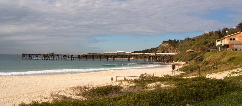 © Peter Ellis
The spot
Community-maintained
Community contribution: submitted by Daniel
Know before you go
Logged by the community, confirmed by mods
Moderate risk: Variable currents around jetty
Tidal currents can be strong around the jetty pilings and headland, especially on outgoing tides. Snorkelers should be aware of changing conditions.
Low risk: Boat traffic
The area near the wharf and jetty sees boat and fishing vessel traffic. Snorkelers should stay visible and be cautious.
Low risk: Depth variation
Depths range from 3 to 30 metres within a short distance. Less experienced snorkelers should stay in shallower inshore areas.
Low risk: Rocky platform entry
Entry is via a rock platform which can be slippery and uneven. Care needed when entering and exiting the water.
Wildlife Guide
No wildlife notes for this spot yet.
Gallery
1 photo from the community
Getting in
Shore entry
Entry
From the Pacific Highway turn onto Flowers Drive and follow it to Catherine Hill Bay Beach. Park near the beach carpark and walk south toward the headland and the historic jetty/wharf structure.
Parking & facilities
Free street parking available along Flowers Drive and near Catherine Hill Bay Beach carpark.
parkingtoilets
Free access. No entry fee.
Spot Map
Community
Gallery ┬╖ 1 photos
Trust
Is this spot real, accurate, still loved?
Spots near New South Wales

No nearby spots yet.
Needs verification
Quick verify
One tap helps the community keep this spot honest.
About this data
- Conditions last evaluated
- Spot data last updated
- Data sources
- Open-Meteo (marine & weather conditions), tide predictions via UTide, community contributors (descriptions, hazards, marine life).
- License
- Spot content licensed under CC BY-SA 4.0. How's the Spot is open source.
Weather & swell ┬╖ Open-Meteo marine & weather APIs Tides ┬╖ UTide harmonic analysis Sea & safety ┬╖ community reports